Context
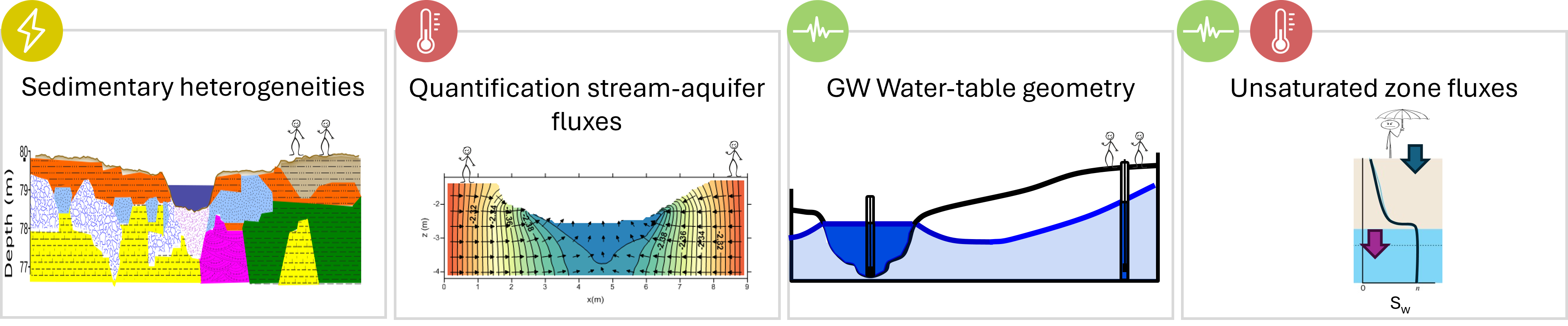
The strategic importance of hydrosystems for global water, food, and energy security will probably intensify under global change (climate-driven and anthropogenic effects, (Castilla-Rho et al., 2017).. Groundwater (GW) systems exist in dynamic balance with the climate and human pressure, connecting interfacing zones of recharge and discharge with multiple feedbacks. Quantifying the water flows in these interfaces is a key issue for hydrogeologists to consider the safe yield and good water quality, especially in view of the ongoing changes in climate and land use (Blöschl et al., 2019). The GW flow model requires spatially continuous and consistent datasets of the hydrofacies that control the movement of water (Condon et al., 2021). Part of our ignorance comes from the fact that the GW flows occur below our feet which still represent a terra incognita (Kleinhans et al., 2005). We need to consider the frequency and duration of extreme events such as floods, heatwaves and droughts which impact the vadose zone (VZ) and Surface Water and Groundwater (SW-GW) interfaces nonlinear physical processes.
Objectives
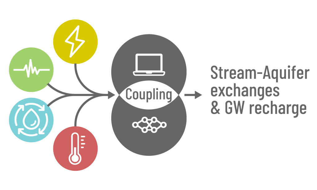
The main objective of GWSBOUND is to provide monitoring and predictive tools of the spatiotemporal
variability of the hydrodynamics in the VZ and the SW-GW continuum under the global
change.
Scientific barrier to be lifted : Quantifying the water flows in the groundwater-interfacing zones of recharge and discharge
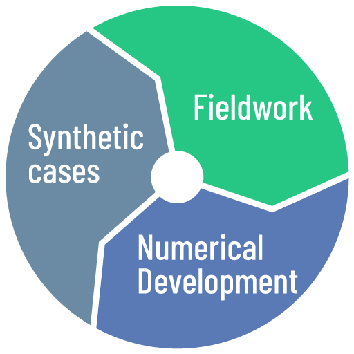
Methodology
Numerical forward model > Phenomenological analysis > Measures (field) > Simulations > Predictions
News
Rejoignez-nous à l'EGU 2025 à Vienne du 27 avril au 2 mai !
Proposée par Agnès Rivière, Anne Jost & Ronan Abhervé
#groundwater #critical_zone #observatories
Team


Vita Clinquart
Master Thesis
Master thesis/ PhD / Post-Doc offers
If you are looking for a postdoc, PhD or graduate student position, and are passionate about water resources issues, enjoy working outside, and are interested in developing your quantitative hydrogeology/hydrology abilities, please contact me directly.
1 open Positions at Mines Paris - PSL and/or Sorbonne Université, France
Master Thesis in hydrogeophysical programming
Master Thesis in hydrogeophysicalEquipment and field works
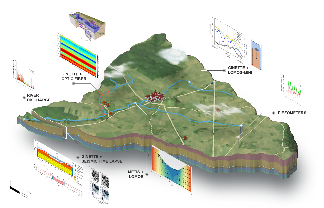
Orgeval Critical Zone Observatory
The Orgeval basin is representative of the agricultural head catchments of the Seine basin. The questions of this territory are the occurrence of severe weather events, agricultural practices (such as fertilizer, pesticides, drainage systems, and land cover), and the transformation of the basin in response to climate change. It is located in the 'Brie et deux Morins' natural park, where over 80% of its area is dedicated to agriculture. The proliferation of large-scale crop has led to a reduction in traditional livestock farming practices and the massive draining.
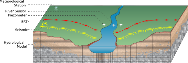
To understand the environmental change, my colleague and I installed numerous equipment: piezometers, river discharge stations, meteorological stations, soil moisture sensors, and temperature sensors. In addition, we use heat as a tracer of water flow (LOMOS -Mini) to monitor the stream-aquifer in one dimension, time lapse seismic acquisition to monitor the flow path in the river corridor , and electrical resistivity tomography to monitor heterogeneity in the subsurface. All theses measurements produce data that we use in numerical model to estimate the water flow and heat transport.
Time-Lapse Seismic Acquisition
The study is described in Dangeard et al. 2021 ⟨10.1029/2020WR028911⟩
New geosphones
Softwares
Forward models
-
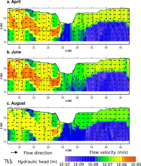
Ginette : hydrothermal code

Ginette is a 2-D variably saturated groundwater flow model with integrated 1-D surface flow for the stream. It rigorously simulates water, energy, and solute transport fluxes in porous media using physically-based equations.
- Wave propagation models
Seismic_CPML 2D et 3D : (acoustic, (an-)istropic, viscoelastic and poroelastic model
It is an open-source Fortran90 programs to solve the two-dimensional or three-dimensional acoustic, isotropic or anisotropic elastic, viscoelastic or poroelastic wave equation using a 2nd/4th or even 8th order finite-difference method in space with Convolutional or Auxiliary Perfectly Matched Layer (C-PML or ADE-PML) conditions, developed by Dimitri Komatitsch and Roland Martin from CNRS, France (GPL-License3.0)
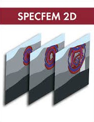
SPECFEM2D allows users to perform 2D and 2.5D (i.e., axisymmetric) simulations of acoustic, elastic, viscoelastic, and poroelastic seismic wave propagation or coupled acoustic-(an)elastic-poroelastic media, with Convolution PML absorbing conditions. The package can also be used for full waveform imaging (FWI) or adjoint tomography.
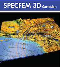
SPECFEM3D_Cartesian simulates acoustic (fluid), elastic (solid), anelastic, coupled acoustic/elastic, poroelastic or seismic wave propagation in any type of conforming mesh of hexahedra (structured or not.) It can, for instance, model seismic waves propagating in sedimentary basins or any other regional geological model following earthquakes. It can also be used for non-destructive testing or for ocean acoustics.
Geostatistical platform

gstlearn :
It is the new cross-platform Geostatistics C++ library proposed by MINES Paris - PSL University. It offers to users all famous Geostatistical methodologies developed and/or invented by the Geostatistic Team of the Geosciences Research Center.
The name 'gstlearn' stands for several purposes: GeoSTatistics & Machine Learning Library; Geostatistical Spatio-Temporal Learning and Learning Geosciences & Spatio-Temporal Models
Processing the raw data
- Deep learning-based P-wave first arrival picking
- SWIP
- probabilistic inversion
- Eikonal solver
SWIP provides an integrated workflow for surface-wave dispersion inversion and profiling.
FTeik 2D and 3D Eikonal solver to compute first arrival traveltimes in a heterogeneous isotropic velocity model, with the possibility to use different grid spacing in all directions.
Databases
Note that the two databases are linked to the THEIA-Land data portalHydrological and hydrogeological Database : bdoh ORACLE
Piezometric, river discharge, temperature profiles and seismic data will be regularly updated into this database
Geophysical Database : H+
Publications
Conferences
Contacts
Contact me at agnes.riviere@minesparis.psl.eu
ANR-23-CE01-0004